Definition of a city
This new definition works in four basic steps and is based on the presence of an 'urban centre' a new spatial concept based on high-density population grid cells.
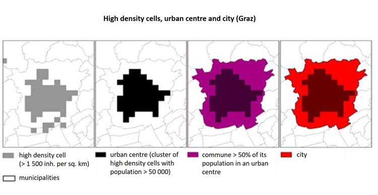
Step 1: All grid cells with a density of more than 1 500 inhabitants per sq. km are selected.
Step 2: The contiguous* high-density cells are then clustered, gaps** are filled and only the clusters with a minimum population of 50 000 inhabitants are kept as an 'urban centre'.
* Contiguity for high-density clusters does not include the diagonal (i.e. cells with only the corners touching).
** Gaps in the high-density cluster are filled using the majority rule iteratively. The majority rule means that if at least five out of the eight cells surrounding a cell belong to the same high-density cluster it will be added. This is repeated until no more cells are added.
Step 3: All the municipalities (local administrative unit level 2 – LAU 2) with at least half their population inside the urban centre are selected as candidates to become part of the city.
Step 4: The city is defined ensuring that: a) there is a link to the political level, b) at least 50% of the city population lives in an urban centre and; c) at least 75% of the population of the urban centre lives in a city.
In most cases, as for example in Graz, the last step is not necessary as the city consists of a single municipality that covers the entire urban centre and the vast majority of the city residents live in that urban centre. To ensure that this definition identified all the relevant centres, the NSIs were consulted and minor adjustments, consistent with this approach, were made where needed. For example: if a LAU boundary (or national border) crosses a grid cell, the population of the grid cell is usually assigned to the LAU where the grid centroid is located. NSIs are welcome however to provide more accurate information which can lead to a split of the population within the grid cell. The degree of urbanisation and the city definition are likely to be highly stable over time in the European context (slow population change and a low speed of urbanisation). Therefore, the updates do not need to occur very frequently. Given the data requirements (population grid, commuting data), it should be updated at least once every decade. If an NSI wants to, they can carry out an update of the degree of urbanisation after five years if a new grid is available. In case any LAU boundaries change, in this instance, an annual update of the degree of urbanisation is needed. If an NSI wishes to, it can apply the degree of urbanisation to a higher resolution grid (200 m or 100 m). Both approaches should lead to a consensus on the degree of urbanisation.
In 2016, Eurostat conducted the last update of the classification of the degree of urbanisation, the so-called DEGURBA classification, on the basis of the 2011 European population grid and EBM 2014. After updating the degree of urbanisation, it is also necessary to update the list of cities. Eurostat and NSIs provided that all LAUs coded 1 in the classification of the degree of urbanisation are put on the list of cities as Cities or parts of Greater cities.